
|
|
 |
|
||||||
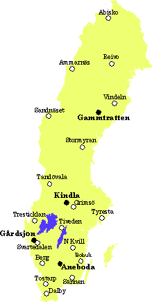
| Sites where integrated monitoring of any form has been conducted since 1981. At four sites with bold-text names IM is presently running, at the others it has been finished or postponed for indefinite time. |
| In the table both the old and the current (bold text) PMK/IM sites are listed in order from north to south. |
| site |
code |
latitude | longitude |
|
year |
ha |
biome | dominant vegetation |
| Abisko Slått. |
|
|
|
|
|
alpine | alpine heath | |
| Abisko Ridonj. |
|
|
|
|
|
subalpine | subalp. birch forest | |
| Ammarnäs fjäll |
|
|
|
|
|
|
alpine | alpine heath |
| Ammarnäs skog |
|
|
|
|
|
|
subalpine | subalp. birch forest, mire |
| Reivo |
|
|
|
|
|
|
mid boreal | mixed conif. forest, mire |
| Vindeln Svartb. |
|
|
|
|
|
|
mid boreal | mixed conif. forest |
| Vindeln Kulb. |
|
|
|
|
|
|
mid boreal | mixed conif. forest |
| Gammtratten |
|
|
|
|
|
|
mid boreal | mixed conif. forest, mire |
| Sandnäset |
|
|
|
|
|
|
N-S-boreal | conif.-decid. forest, mire |
| Stormyran |
|
|
|
|
|
|
mid boreal | mixed conif. forest, mire |
| Tandövala |
|
|
|
|
|
|
mid boreal | mixed conif. forest, mire |
| Kindla |
|
|
|
|
|
|
S boreal | mixed conif. forest, mire |
| Grimsö |
|
|
|
|
|
S boreal | mixed conif. forest, mire | |
| Tyresta |
|
|
|
|
|
boreonem. | mixed conif. forest, mire | |
| Tresticklan |
|
|
|
|
|
|
boreonem. | Scots pine forest |
| Tiveden |
|
|
|
|
|
|
boreonem. | mixed conif. forest,mire |
| Gårdsjön |
|
|
|
|
|
|
boreonem. | mixed conif. forest |
| Svartedalen |
|
|
|
|
|
|
boreonem. | mixed conif. forest, mire |
| N Kvill |
|
|
|
|
|
boreonem. | mixed conif. forest | |
| Bohult |
|
|
|
|
|
boreonem. | mixed conif. forest | |
| Aneboda |
|
|
|
|
|
|
boreonem. | mixed conif. forest, mire |
| Berg |
|
|
|
|
|
|
boreonem. | conif.+ decid. forest, bog |
| Sännen |
|
|
|
|
|
boreonem. | mixed conif. forest | |
| Tostarp |
|
|
|
|
|
|
nemoral | beech forest |
| Dalby |
|
|
|
|
|
nemoral | mixed decid. forest |
More information on the former sites may be obtained from contact persons at the Department of Environmental Assessment, SLU. |